

PLAN YOUR RIDE
Travel to Puerto Peñasco
Practical border, highway and safety information for a smoother Rally trip.PLANEA TU VIAJE
Viaja a Puerto Peñasco
Información práctica de frontera, carretera y seguridad para disfrutar mejor tu viaje al Rally.Crossing the border
Carry your passport or passport card, motorcycle registration and identification where they are easy to reach. Weapons and ammunition are prohibited when entering Mexico.
Cruce fronterizo
Lleva a la mano pasaporte o tarjeta pasaporte, registro de la motocicleta e identificación. Está prohibido ingresar armas y municiones a México.
Getting here
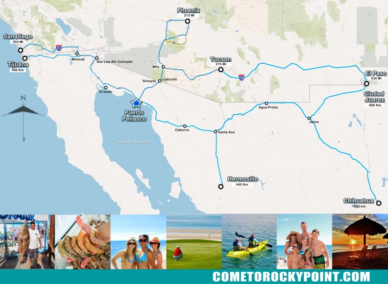
Puerto Peñasco is approximately 65 miles south of the Lukeville, Arizona / Sonoyta border crossing. From Sonoyta, continue south on Mexico Highway 8.
Cómo llegar
Puerto Peñasco está aproximadamente a 65 millas al sur del cruce fronterizo Lukeville, Arizona / Sonoyta. Desde Sonoyta continúa hacia el sur por la carretera México 8.
Choose your route
Elige tu ruta
Take I-10 west to Exit 112, then Highway 85 south through Gila Bend, Ajo and Why to Lukeville. From southern Phoenix, AZ 347, AZ 84 and I-8 also connect toward Gila Bend.
Take Ajo Way / AZ 86 west through Sells to Why. Turn left onto Highway 85 south and continue to the Lukeville crossing.
From the border near San Luis Río Colorado, take Mexico Highway 2 east to Highway 003 toward Golfo de Santa Clara and Puerto Peñasco. Sections may include toll roads.
Documents and travel tools
Carry a valid passport or passport card for your return to the United States. Confirm Mexican motorcycle insurance, current border hours, road conditions and fuel availability before departing.
OPEN INTERACTIVE MAP →U.S. BORDER WAIT TIMES →PASSPORT INFORMATION →READ THE FAQ →Documentos y herramientas
Lleva pasaporte o tarjeta pasaporte vigente para regresar a Estados Unidos. Confirma seguro mexicano para motocicleta, horarios fronterizos, condiciones de carretera y disponibilidad de combustible antes de salir.
ABRIR MAPA INTERACTIVO →TIEMPOS DE ESPERA FRONTERIZOS →INFORMACIÓN DE PASAPORTE →LEER PREGUNTAS FRECUENTES →